 |
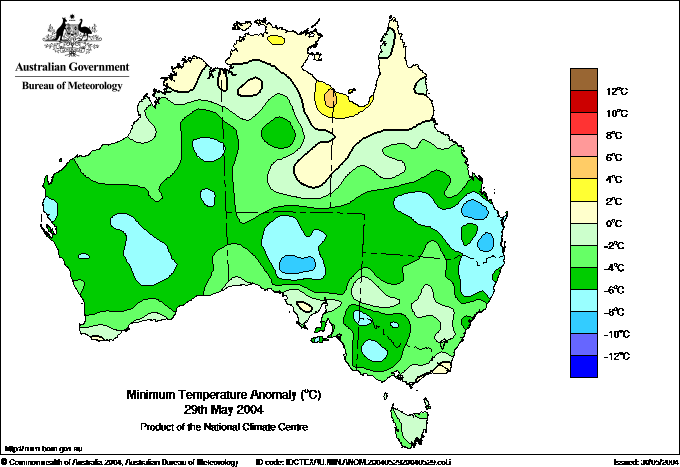
 Minimum
temperature departures from normal today (above). Only the far north
of the continent is above average, with the coldest temperatures relative
to normal in SE QLD and central SA. Minimum
temperature departures from normal today (above). Only the far north
of the continent is above average, with the coldest temperatures relative
to normal in SE QLD and central SA. 
 Actual minimum
temperatures (below). Frost level temperatures (below
about 3° and
shaded grey or pink) stretch across 6 states, an unusually broad area
to receive frost on the one morning. BoM Actual minimum
temperatures (below). Frost level temperatures (below
about 3° and
shaded grey or pink) stretch across 6 states, an unusually broad area
to receive frost on the one morning. BoM |
 |
 The
maximum temperature departure from normal map (below)
is even more remarkable, with only the tip of Cape York Peninsula and
the far south of WA recording
temperatures just above normal. A huge area of northern WA and the NT
experienced daytime temperatures 10 to 16° below average. BoM The
maximum temperature departure from normal map (below)
is even more remarkable, with only the tip of Cape York Peninsula and
the far south of WA recording
temperatures just above normal. A huge area of northern WA and the NT
experienced daytime temperatures 10 to 16° below average. BoM |
 |
 Widespread
cold sets records in NT, northern WA Widespread
cold sets records in NT, northern WA
Over 90% of the continent experienced below average minimum and maximum
temperatures today. In an area from Broome and the Kimberley in WA southeast to around Alice Springs,
the day was the coldest, or one of the coldest, May days on record (see map  ). ).
Residents
of Broome, accustomed to tropical warmth, reached for doonas and ugg boots
as thick cloud, wind and rain accompanied the coldest May day in 64 years
of observations at the Airport. The previous record was 19.8 on 10 May 1997.
Wyndham
only just reached record territory with a top of 21.0, 0.1 below the previous
record in 34 years of observation. In the Territory, in an area
extending through the Tanami Desert to Alice Springs,
maximum temperatures struggled to reach double figures. Rabbit Flat Roadhouse
registered 13.0°, 2.5 below the previous May record in 34 years. At Yuendumu,
260km NW of Alice Springs, the mercury only reached 9.2°,
15.9 below normal and well below the settlement's previous lowest May maximum
of 12.2
in 35 years of record. Alice Springs recorded a top of 11.1 at the airport,
just 0.6 above their coldest May day in 62 years of record. The maxima at Alice
Springs for the
five days May 26 to 30 were 14.5, 14.7, 13.0, 11.1 and 12.7 compared to the
May average of 23.0. Unfortunately, many weather stations in this
relatively uninhabited part of Australia are fairly new, with computerised
data only going back up to 15 or 20 years.
For most of these, the record was well below the previous lowest May maximum.
For example, Kununurra Airport has 18 years of record; the maximum today
was 21.4 while the previous record was 25.1.
The reasons for the rare pre-winter cold are complex. Firstly, colder southern
air has gradually been invading the continent from the south, swinging to
the northwest across western tropical Australia. More importantly,
much of The Centre has experienced heavy cloud cover for most of the past
10 days,
an
unusually
long time to block solar radiation surface heating. Widespread rain in this
area
dragged colder air from aloft to the surface and also
formed a vast field of low-level cloud which became visible on infrared satellite
images yesterday as the upper cloud deck moved away to the east. This low-level
cloud, with its captive colder air beneath, drifted northwest into the Kimberley
yesterday and today. The arrival of the cold surface air over the North Kimberley
late yesterday resulted in the formation of a tropical depression
over warm waters off the Kimberley coast early this morning, sending
bands of thick
middle
and
high
level
cloud
streaming across the Kimberley today, further reducing solar radiation and
helpiing to keep the low level cloudmass intact. Heavy rain from the low
would also have dragged down further cooler air from aloft --
Faraway Bay in the North Kimberley recorded 88mm in the 24 hours to 9 this
morning,
while
Kalumburu
Mission,
70km SW,
recorded
43mm
between 9am and 3pm.
In subtropical parts of the country, cold dry conditions settled in following
the cold front that moved through the southeast yesterday. The unusually
elongated high, covering southern WA, all of SA, and ridging to southern
QLD, produced another night of unusually widespread frost in WA, SA, TAS,
VIC, NSW and SE QLD (see map  ).
These were particularly severe on the NSW Northern Tablelands where Glen
Innes Airport recorded a low of -7.3. The
greatest
minimum temperature
departures from normal were in SE QLD, where Coolangatta Airport, which is
just behind the beach, recorded a low of 4.1, 10.5 below average. North of
Brisbane, Gympie set a new May minimum record of 0.6 in 38 years of computerised
observations. Kingaroy (-1.9) and Warwick (-1.5) recorded the lowest air
temperatures, but many stations in the Granite Belt, Darling Downs and Central
Highlands recorded sub-zero grass minima. The lowest were -3.5 at Monto,
-3.2 at Tambo,
-2.8 at Taroom, -2.7 at Mitchell and -2.5 at Dalby. ).
These were particularly severe on the NSW Northern Tablelands where Glen
Innes Airport recorded a low of -7.3. The
greatest
minimum temperature
departures from normal were in SE QLD, where Coolangatta Airport, which is
just behind the beach, recorded a low of 4.1, 10.5 below average. North of
Brisbane, Gympie set a new May minimum record of 0.6 in 38 years of computerised
observations. Kingaroy (-1.9) and Warwick (-1.5) recorded the lowest air
temperatures, but many stations in the Granite Belt, Darling Downs and Central
Highlands recorded sub-zero grass minima. The lowest were -3.5 at Monto,
-3.2 at Tambo,
-2.8 at Taroom, -2.7 at Mitchell and -2.5 at Dalby.
 Late
season depression brings heavy rain to WA Kimberley Late
season depression brings heavy rain to WA Kimberley
A tropical depression that formed about 250km north of Derby this
morning gave some heavy late-season falls along the north Kimberley coast
around Kalumburu. In
the 24 hours to 9am, Faraway Bay, 72km NE of Kalumburu,
recorded 88.0mm while Truscott, 36km NW of Kalumburu,
recorded
59.0mm.
Mean monthly rainfall for May along this section
of the coast is between 25 and 50mm, and falls this large so late in the
month are rare. Troughton Island, 80km NW of Kalumburu, recorded 60mm of
steady moderate rain from around 9pm yesterday to 3pm today. Wind at the
island's 9am and noon observations averaged 52km/h. Of Truscotts 24 hour
total of 59mm, 32mm fell between 6 and 9am and there was a further
16mm between 9am and midday. Kalumburu Mission recorded 43mm between 9am
and 3pm. |

